Geographical position

Geographical position
Zrenjanin is situated on the western edge of the Banat loess plateau, at the place where the canalized River Begej flows into the former water course of the River Tisza. The territory of the municipality is pronouncedly flat country. The City of Zrenjanin is situated at a longitude of 20°23’ east and a latitude of 45°23’ north, in the center of the Serbian part of the Banat region, on the banks of the Rivers Begej and Tisza. The city is located at 80 meters above sea level.
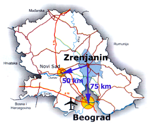
Zrenjanin is around 70 kilometers away from Belgrade, and about 50 kilometers from Novi Sad, which is also the distance to the present border with the European Union (Romania), which makes its position a particularly important transition center and potential resource in the directions north – south and east – west.